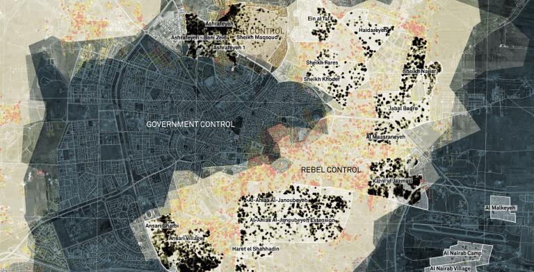
Conflict Urbanism Aleppo project has been featured in “‘An Entire Archive of Our Life.’ Saving the Record of Syria’s War”
Conflict Urbanism Aleppo project has been featured in “‘An Entire Archive of Our Life.’ Saving the Record of Syria’s War”
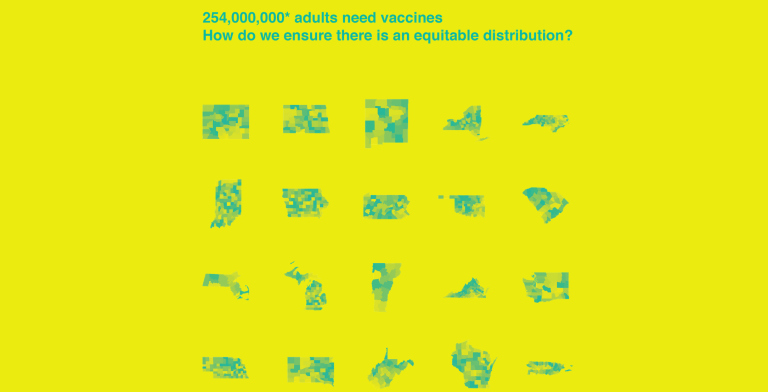
An interactive map of each county in each state proposing how COVID-19 vaccinations could be distributed is now publicly available, providing an important tool for policymakers and the public alike to analyze the differences between multiple distribution strategies as well as issues surrounding equity and vulnerability of at-risk groups.

The Center for Spatial Research at Columbia University (CSR) is pleased to announce funding to support the development of new courses that focus on topics related to spatial inequality at Columbia University. Proposals for new courses to be offered during the 2021-2022 academic year are due February 23, 2021.
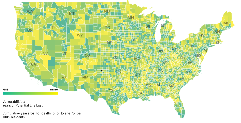
Mapping the New Politics of Care is a visual journey through the inequities and vulnerabilities that define the American landscape, using different definitions to describe communities at risk, down to the county level. The project is also designed to show visitors how the areas that appear most at risk within each state shifts depending on how vulnerability is measured: from COVID-19 cases to unemployment rates, from COVID-19 deaths to formal metrics of health vulnerability such as Years of Potential Life Lost and the Centers for Disease Control and Prevention’s Social Vulnerability Index.

The Center for Spatial Research at Columbia University (CSR) is pleased to announce funding to support the development of a new Spring 2020 course with a focus on topics related to spatial inequality at Columbia University. Proposals for new courses are due April 5, 2019. Through support from the Andrew W. Mellon Foundation selected faculty will receive $15,000 in summer salary towards course development. All full-time Columbia University faculty, at any rank, are eligible to apply.

The Center for Spatial Research is pleased to announce a new $1 million grant received from the Robert David Lion Gardiner Foundation to create web-based, interactive maps of Manhattan and Brooklyn during the late 19th and early 20th centuries. The three-year project is a collaboration of Columbia’s History Department and the Columbia Center for Spatial Research in the Graduate School of Architecture, Planning and Preservation (GSAPP).
Students from Laura Kurgan’s fall 2016 #CLOSErikers Advanced Architecture studio, Clara Dykstra and Stella Ioannidou published their research “After Arrest” as part of Urban Omnibus’s new series, The Location of Justice, which examines “the pervasive and often overlooked infrastructure of criminal justice in New York and the spaces that could serve a more just city.”
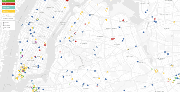
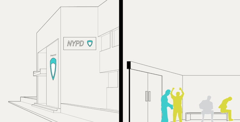
The Center for Spatial Research, with Urban Omnibus, has just published an interactive map that locates the diverse sites and institutions that comprise the New York City criminal justice system. The map is part of Urban Omnibus’s new series, The Location of Justice, which examines “the pervasive and often overlooked infrastructure of criminal justice in New York and the spaces that could serve a more just city.”

The Center for Spatial Research is pleased to announce our selection with the Brown Institute as inaugural recipients of Columbia University’s Collaboratory Fellows Grant for Points Unknown: New frameworks for investigation and creative expression through mapping.
CSR researchers and students and steering committee members participate in map-a-thon to assist with the humanitarian crisis in Puerto Rico featured by PBS NewsHour: "Volunteers are helping Puerto Rico from home, with a map anyone can edit"