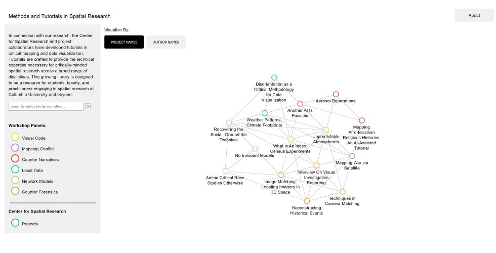
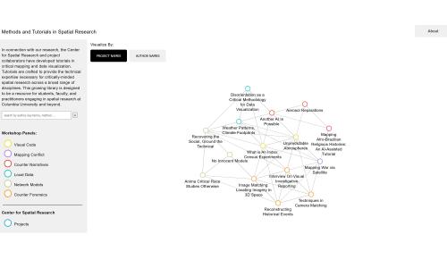
In connection with our research, the Center for Spatial Research and project collaborators have developed tutorials in critical mapping and data visualization. Tutorials are crafted to provide the technical expertise necessary for critically-minded spatial research across a broad range of disciplines. This growing library is designed to be a resource for students, faculty, and practitioners engaging in spatial research at Columbia University and beyond.
Thank you to the core group of workshop speakers: Alison Killing, Ana Paulina Lee, Beth Coleman, Bobby Pietrusko, Catherine D'ignazio, Dan Miller, Ezekiel Dixon-Roman, Guangyu (Tim) Wu, Jamon Van Den Hoek, Jia Zhang, Lucia Rebclino, Maksym Rokmaniko, Mitch McEwen, Mona Fawaz, Nicholas Masterton, Sasha Engelmann, Sophie Dyer, Wendy Hui Kyong Chun, and Yanni Loukissas. Please see the link here for workshop contributors' bios.
Workshop Organizers: Laura Kurgan and Adeline Chum
Exostructures
Ethan Davis, Leon Duval, Yani Gao, Tristan Gong, Sanober Khan, Junho Lee, Shan Li, Shulong Ren, Hyuein Song
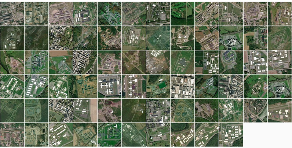
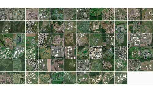
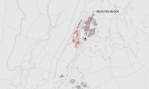
With a 56% reduction in prison population since 2000, 26 prisons in New York State have closed and more are set to be closed. Layering these closures with policies, economic and community impact, pushback, political positions, environmental concerns, as well as the decentralization of the criminal justice system, this research seeks to envision post-prison futures in the rural towns of upstate New York. It also explores the flows and transfers through the prison economy that interconnect these towns and New York City. A range of visions focus on prisons, towns or the system of mass incarceration, and consider state infrastructures- carceral, water, food, power, waste- as urban exostructures.
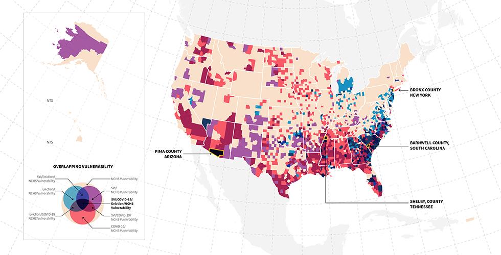
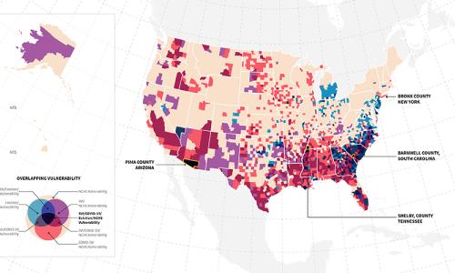
Staying Power is a toolkit of research and proposals aimed at fostering a network of care to both prevent evictions and empower tenants who are in the process of being evicted. The project analyzes systems of eviction before and during the COVID-19 pandemic and uses nationwide health data to identify areas of extreme vulnerability. Building on this research, the toolkit is a set of interconnecting proposals designed specifically for the Bronx, addressing the eviction system at multiple leverage points using existing networks of care and a proposed team of Community Health Workers.
Research Towards a New Politics of Care
Caitlin Blanchfield, Adeline Chum, Nelson De Jesus Ubri, Nadine Fattaleh, Spenser A. Krut, Adam Vosburgh
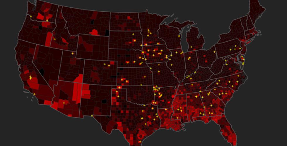
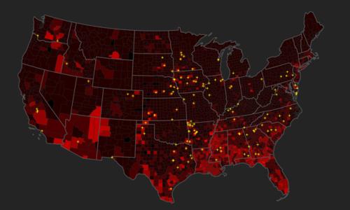
Over the summer of 2020, researchers at the CSR investigated patterns in the distribution of COVID-19 while critically questioning the role of mapping and data visualization in understanding the pandemic. The research sought to match the COVID-19 count data at the county level with various other datasets to spatially explore patterns and trends in the spread of the virus across multiple scales.
Weak Ties: the Urban History of an Algorithm
Laura Kurgan, Dare Brawley, Jia Zhang, Wendy Hui Kyong Chun
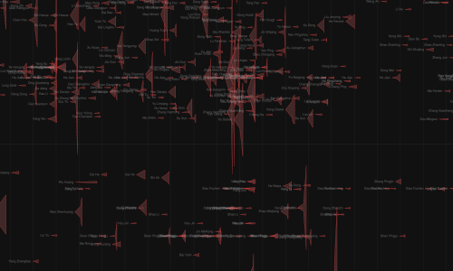
Whether it is online or in our daily physical routines, we interact with others—close friends, acquaintances, familiar and unfamiliar strangers—in ways that over time come to show patterns. Network theory represents these relationships as graphs, using the visual language of ties (lines) connecting nodes (circles) to describe the topography and dynamics of families, friendship groups, workplaces, neighborhoods, and communities. The “strength of weak ties,” like other central network science concepts such as homophily, drew from ethnographic studies within mid-century urban sociology. If homophily, the idea that similarity breeds connection, underlies the polarization that occurs in many online networks, weak ties can be used to combat polarization and acknowledge—even activate—the fact that we live in a world of difference. Weak ties offer a way to engage the rich ambivalence that pervades everyday interactions with acquaintances.
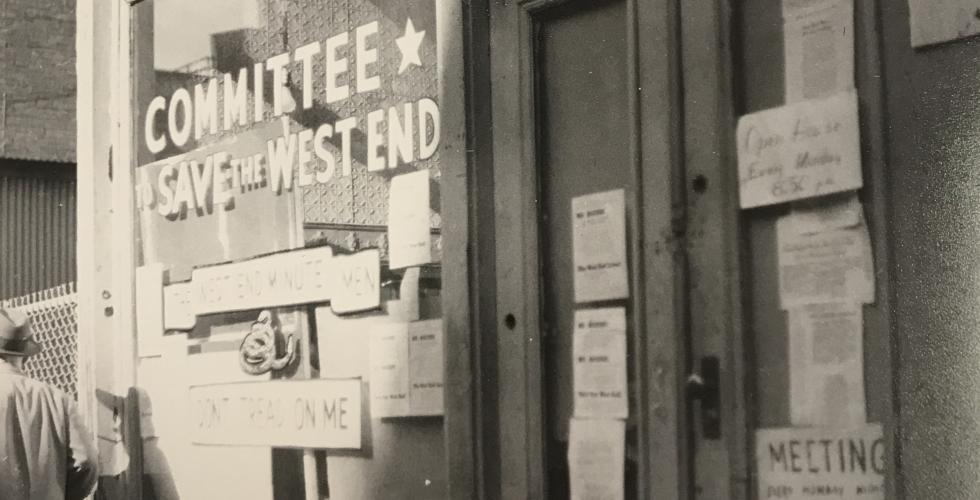
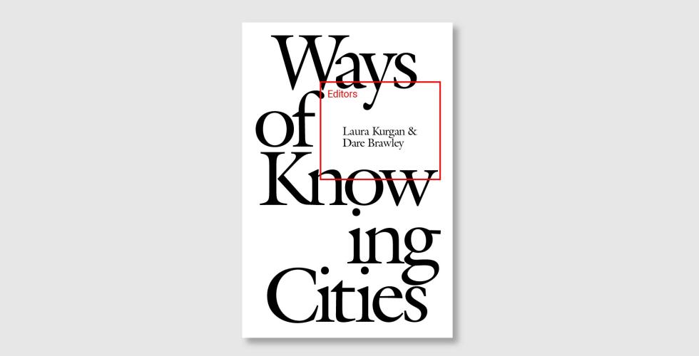
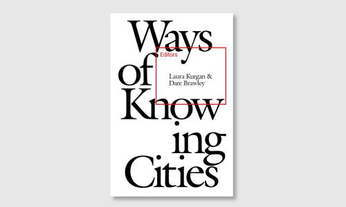
Ways of Knowing Cities considers the role of technology in generating, materializing, and contesting urban epistemologies—tracing an arc from ubiquitous sites of “smart” urbanism, to discrete struggles over infrastructural governance, to forgotten histories of segregation now naturalized in urban algorithms, to exceptional territories of border policing. Bringing together architects, urbanists, artists, and scholars of critical migration studies, media theory, geography, anthropology, and literature, the essays stage a deeply interdisciplinary conversation, interrogating the ways in which certain ways of knowing are predicated on the erasure of others.
Homophily: the Urban History of an Algorithm
Laura Kurgan, Dare Brawley, Jia Zhang, Brian House, Wendy Hui Kyong Chun
An article in e-flux Architecture on the urban origins of the term homophily, its formalization and proliferation through the algorithmic logics of online networks, and the risks we run when it becomes not just a descriptive model but a prescriptive rule for social life. Published in conjunction with an exhibition for the 2019 Chicago Architecture Biennial.
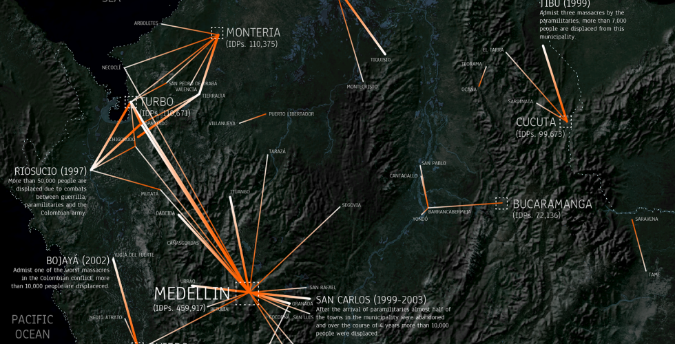
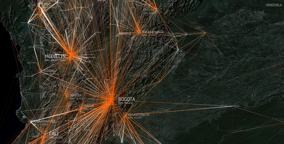
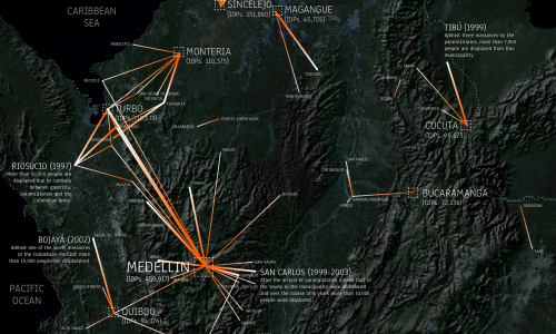
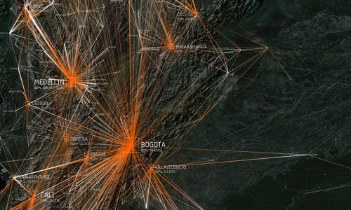
A Gravity Model Analysis of Forced Displacement in Colombia
Juan Francisco Saldarriaga, Yuan Hua
Conflict Urbanism
Cities: The International Journal of Urban Policy and Planning
An article analyzing internal displacement in Colombia was published in Cities in summer 2019. Between 1985 and 2016 more than 7 million people were victims of forced displacement in Colombia. At the height of the conflict, more than 90% of municipalities in the country saw some form of displacement. In this study we extend the traditional gravity model of migration to analyze the flows of internally displaced people in Colombia between 1986 and 2015, and identify some of the main factors involved in people's choice of destination.
Visualizing Conflict: Possibilities for Urban Research
Juan Francisco Saldarriaga
Conflict Urbanism
Urban Planning
This article, published by the open access journal Urban Planning, outlines recent work as part of the multiyear Conflict Urbanism project. This article discusses two projects currently under way that use mapping and data visualization to explore and analyze Conflict Urbanism in two different contexts: the city of Aleppo, and the nation of Colombia. Both projects interrogate the world of ‘big data,’ as a means to open up new areas of research and inquiry, but with a particular focus on data literacy as an essential part of communicating with these new forms of urban information.
This article published by Yuca magazine describes the Conflict Urbanism: Colombia project. In it, Juan Francisco Saldarriaga describes how, having grown up in Colombia, working on this project has changed his understanding of the conflict. The article describes the maps, graphs, color pixels, and thickening lines that have shown the size and magnitude of the worst massacres, revealed the moments and events that caused stakeholders to change positions, and made evident the constant and painful journeys of the displaced and other victims.
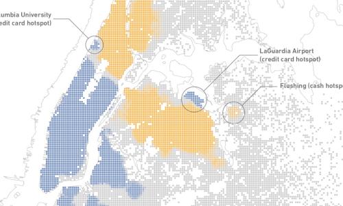
Access to Taxicabs for Unbanked Households: An Exploratory Analysis in New York City
In this paper, we used multiple datasets to explore taxicab fare payments by neighborhood and examine how paid taxicab fares are associated with use of conventional banking services. There are clear spatial dimensions of the propensity of riders to pay cash, and we found that both immigrant status and being “unbanked” are strong predictors of cash transactions. These results have implications for local regulations of the for-hire vehicle industry, particularly in the context of the rapid growth of services that require credit cards to use.
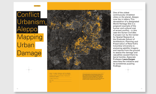
In this article for Architectural Design, Laura Kurgan discusses the Conflict Urbanism: Aleppo project and its sometimes puzzling findings. One of the oldest continuously inhabited cities on the planet, Aleppo now lies in tatters. This devastation of a designated World Heritage Site is a poignant example of the human and cultural cost of armed conflict – in this case the Syrian Civil War. The Center for Spatial Research has analyzed satellite imagery and reports from the ground to assess the damage in Aleppo.
Conflict Urbanism: Colombia
Laura Kurgan, Juan Francisco Saldarriaga, Angelika Rettberg
Conflict Urbanism
After Belonging: The Objects, Spaces, and Territories of the Ways We Stay in Transit
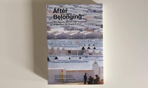
Over the course of the last thirty years, more than 7 million Colombians have left their homes and towns in a search for safety. In this project we plot the trajectories of these Colombians in conflict. This article about our contribution to the 2016 Oslo Architectural Triennale was published in the exhibition’s catalog, After Belonging: The Objects, Spaces, and Territories of the Ways We Stay in Transit.
Almost five years after the start of the civil war in Syria, Aleppo is still under siege. At the time of writing, in February 2016, the few roads into and out of the city are blocked. What are believed to be Russian warplanes have been targeting rebel-held neighborhoods in an effort to help President Bashar al-Assad regain control of the city. Hundreds of thousands of Syrians have been killed or injured, and an estimated nine million people have been displaced. Our research on Aleppo focuses on the urban cost of the civil war, and what it implies for the city to which survivors might one day return.
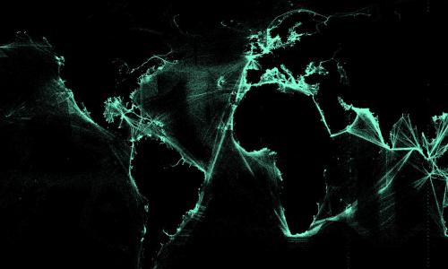
Port to Port
Juan Francisco Saldarriaga, Laura Kurgan, Dare Brawley, Jen Lowe
Ninety percent of all goods worldwide are moved by ship, but shipping is mostly invisible. More than 300 million Metric Tons of energy are shipped in and out of the United States each year, in 60,000 shipments. This project presents the ports and paths of the 2.7 billion Metric Tons of energy shipped through more than 90 US ports from 2002 - 2012. Using data assembled by Thomson Reuters, Port to Port maps global oil shipping routes as well as other forms of energy navigating ocean territories to and from the United States. Using D3 as an interactive web platform we designed a map interface that is scaled globally while embedded with local stories about energy movement from port to port. Data can be viewed across time, which reveal changes in patterns of movement as the geopolitics, price of oil, and conditions at specific ports change.
This project visualizes a relatively new phenomenon: online free expression in China. It examines some innovative strategies employed by users of Weibo, a Twitter–like micro–blogging platform, in order to avoid government censorship bloggers post images as text. Images are much more difficult for automated search programs to analyze, which allows image-based content to spread more widely before it is detected and removed. Taking advantage of this, some users now turning writing into images, taking screenshots of their own and others' controversial posts before they're removed, then posting and re–posting them. The project visualizes Weibo posts that were posted and deleted between September 8th to November 13th, in 2013.
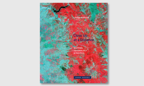
Close Up at a Distance, Mapping Technology Politics
Close Up at a Distance records situations of intense conflict and struggle, on the one hand, and fundamental transformations in our ways of seeing and of experiencing space, on the other.
This is the final report based on work done for a grant titled "Rebuilding Community, Prisoner Reentry and Neighborhood Planning in Post-Katrina New Orleans." The report contains three parts:
1. An Introduction to the concepts of Million Dollar Block maps and Justice Reinvestment.
2. Mapping Incarceration in Post-Katrina New Orleans.
3. A description of the neighborhood planing process and the four pilot projects were were implemented as a result of that process.
The Justice Atlas of Sentencing and Corrections is an online tool for mapping the residential distribution of people involved in the criminal justice system. It uses aggregated address data to map the flow of people being removed to prison, reentering communities from prison, and the standing population concentrations of people under parole or probation supervision.
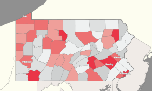
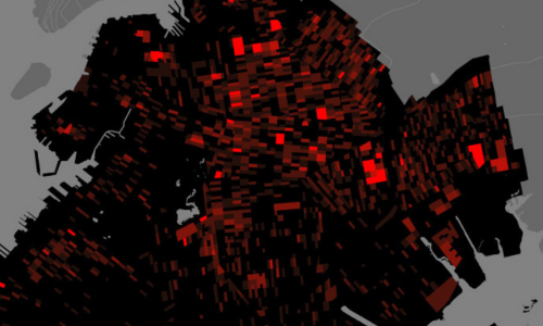
This publication documents the pattern of incarceration in four cities in the United States: Phoenix, Wichita, New Orleans and New York. Building on work already done jointly by the Council of State Governments, the JFA Institute, and the Justice Mapping Center, the lab’s mapping project seeks to help advocates and government officials focus attention on the conditions and needs of urban spaces which show high rates of incarceration.
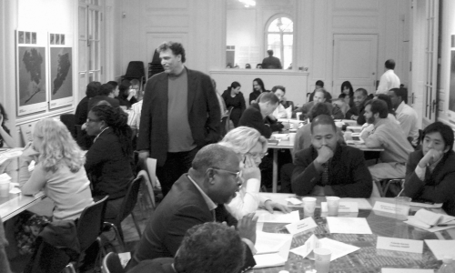
City Council of New Orleans Criminal Justice Committee Meeting
This publication documents the results of a Scenario Planning Workshop, hosted by SIDL and facilitated by the Global Business Network on September 29th, 2006. The workshop took place at the Architectural League of New York as part of the exhibit, Architecture and Justice which was on view from September through October, 2006.
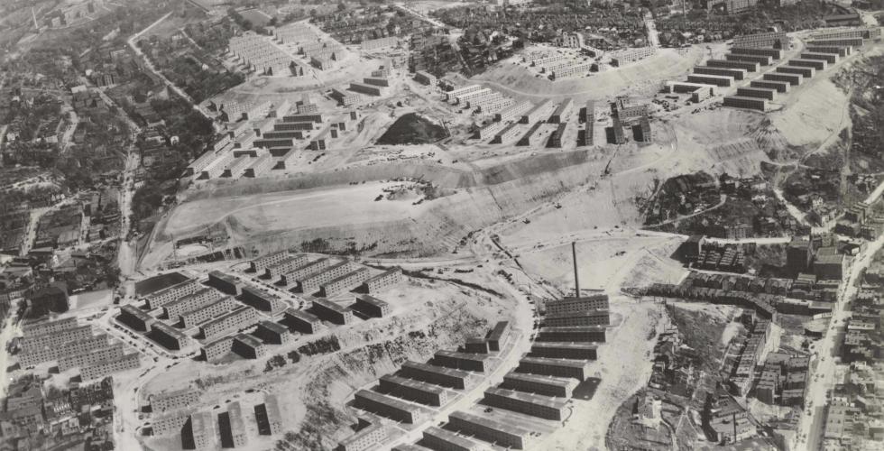
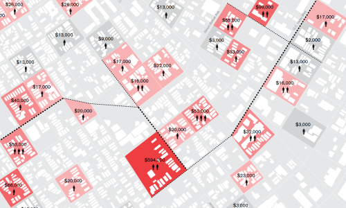
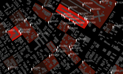
Using rarely accessible data from the criminal justice system, the Spatial Information Design Lab and the Justice Mapping Center have created maps of these “million dollar blocks” and of the city-prison-city-prison migration flow for five of the nation’s cities. The maps suggest that the criminal justice system has become the predominant government institution in these communities and that public investment in this system has resulted in significant costs to other elements of our civic infrastructure — education, housing, health, and family. Prisons and jails form the distant exostructure of many American cities today.
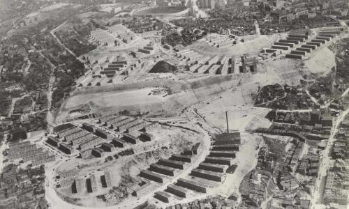
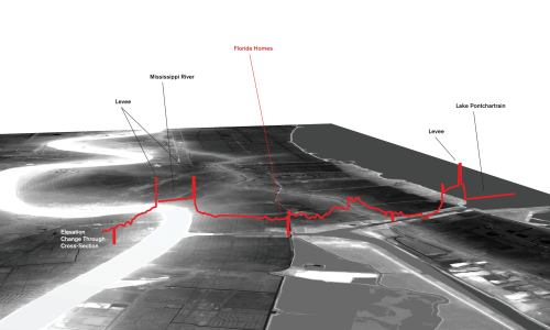
A study of topography, prison admissions and expenditures in New Orleans including a focus on one specific housing project in the Ninth Ward, The Florida Homes.