The Center for Spatial Research offers multiple semester long courses each year that are open to students from GSAPP and the Arts & Sciences as well as an intensive summer session methods workshop for faculty. Our courses are designed to encourage humanities and architecture scholars and students to integrate data-driven approaches into their teaching and research and to foster a new generation of critically-minded data-literate scholars and data-based scholarship.
Spring 2023
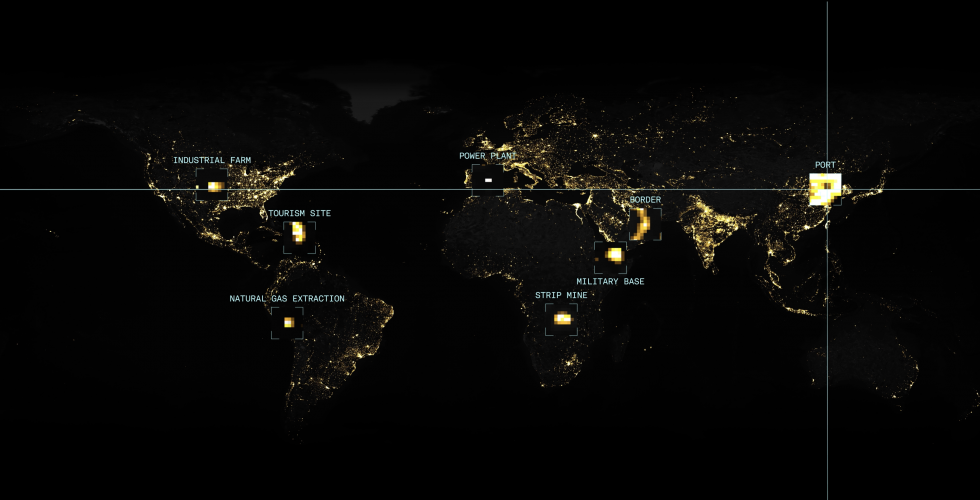
Conflict Urbanism as a term designates not simply that conflict that take place in cities, but also that conflict is a structuring principle of cities, as a way of inhabiting and creating urban space. The theme is topical in light of the increasing urbanization of warfare and the policing and surveillance of everyday life, however, conflict is not limited to war and violence. Cities are not only destroyed but also built through conflict.
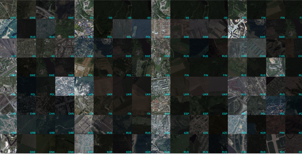
Methods in Spatial Research introduces key concepts required for work with geographic information systems (GIS) and spatial research in the urban humanities.
Spring 2022
Conflict Urbanism as a term designates not simply that conflict that take place in cities, but also that conflict is a structuring principle of cities, as a way of inhabiting and creating urban space. The theme is topical in light of the increasing urbanization of warfare and the policing and surveillance of everyday life, however, conflict is not limited to war and violence. Cities are not only destroyed but also built through conflict.
A seminar exploring attempts to map out the unequal organization of the current world order.
Methods in Spatial Research introduces key concepts required for work with geographic information systems (GIS) and spatial research in the urban humanities.
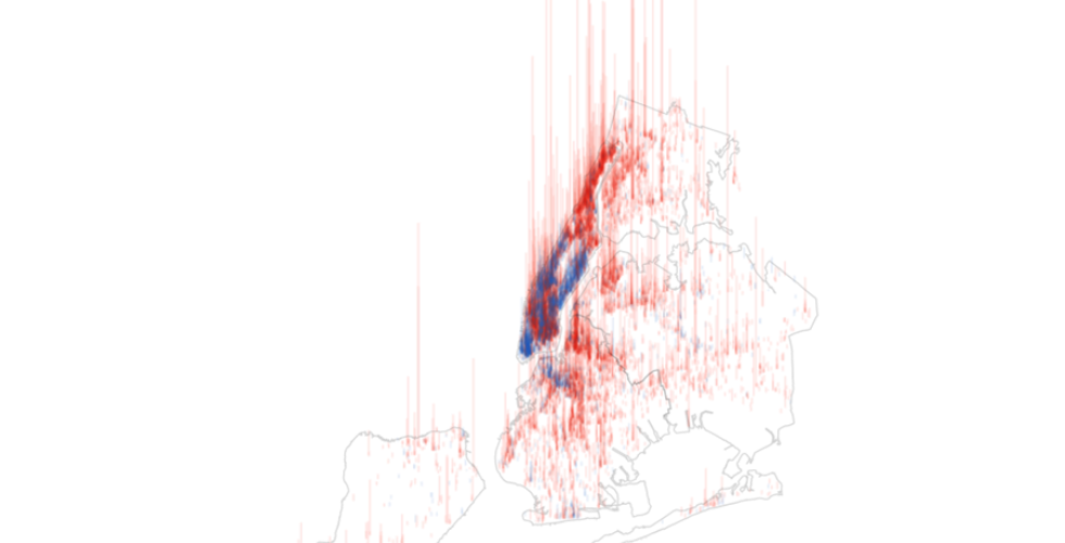
In this course students will explore new forms of site analysis through pairing geospatial analysis, mapping, and storytelling. Society is increasingly dependent on data and computation, a dependence that often evolves invisibly, without any critical assessment or accountability. In New York City, with its mandate to make data public, students have an opportunity to learn how to question data through journalistic lines of inquiry: What data are made public? What do they say about life in the city?
Fall 2021
This course explores the role that migrant communities have historically played in the construction of New York as well as the spatial negotiations, frictions, and conflicts derived from their settlement in the city. Architecture and urban strategies have historically participated in the definition of frameworks of belonging for migrant communities. However, they have also been used as tools for the exclusion of minority communities, as an alibi in xenophobic arguments, and as mediators of assimilationist policies.
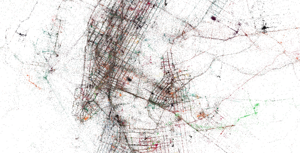
This course introduces key concepts and techniques in interactive data visualization to students who are new to the field of computation and information design. Through a series of in-class exercises and take-home assignments, students will critically engage with visual representations of data and produce interactive visualizations that serve analytical and narrative purposes.
How do historic spatial inequities continue to resonate in the present? In this course we’ll look at the case study of Madagascar’s capital city, Antananarivo to explore how the historic politics of water management continue to inform and inflect the rapid expansion of the city today. We’ll consider the changes and threats to peri-urban agriculture, and map how the agricultural landscape in and around the city is shifting as people increasingly build on the flood plain.
Methods in Spatial Research introduces key concepts required for work with geographic information systems (GIS) and spatial research in the urban humanities.
Spring 2021
Conflict Urbanism as a term designates not simply that conflict that take place in cities, but also that conflict is a structuring principle of cities, as a way of inhabiting and creating urban space. The theme is topical in light of the increasing urbanization of warfare and the policing and surveillance of everyday life, however, conflict is not limited to war and violence. Cities are not only destroyed but also built through conflict.
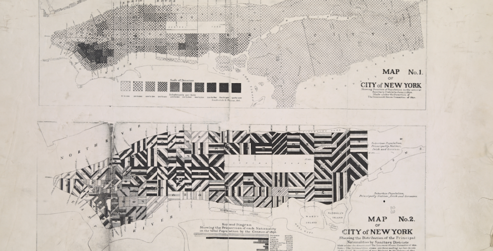
This hybrid theory/practice course provides an introduction to critical mapping discourse and geographic information systems tools. Of particular interest to humanities students, it examines both historical and contemporary questions with reference to the technology of mapping. Additionally, through the use of open-source GIS software (QGIS), browser-based technologies (Mapbox, Mongo DB), and open data (OpenStreetMap), students will learn how to critically use mapping tools and geographic data for spatial analysis and representation.
Methods in Spatial Research introduces key concepts required for work with geographic information systems (GIS) and spatial research in the urban humanities.
In this course students will explore new forms of site analysis through pairing geospatial analysis, mapping, and storytelling. Society is increasingly dependent on data and computation, a dependence that often evolves invisibly, without any critical assessment or accountability. In New York City, with its mandate to make data public, students have an opportunity to learn how to question data through journalistic lines of inquiry: What data are made public? What do they say about life in the city?
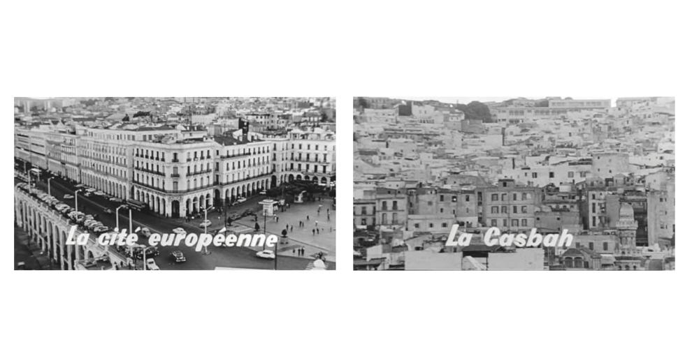
The course is the second in a series of Andrew W. Mellon Foundation-supported seminars on topics related to spatial inequality. This course explores representations of space in contemporary Algerian literature and film, considering how spatial imaginaries engage with changing social and political landscapes.
Fall 2020
This course introduces key concepts and techniques in interactive data visualization to students who are new to the field of computation and information design. Through a series of in-class exercises and take-home assignments, students will critically engage with visual representations of data and produce interactive visualizations that serve analytical and narrative purposes.
This course introduces students to the emerging methodologies that combine geographic information systems (GIS) with historical thinking. Students will study and evaluate the benefits and limitations of key works in historical GIS, become familiar with basic principles of cartographic design, and learn technical skills to create their own HGIS project.
2019-2020
Conflict Urbanism as a term designates not simply that conflict that take place in cities, but also that conflict is a structuring principle of cities, as a way of inhabiting and creating urban space. The theme is topical in light of the increasing urbanization of warfare and the policing and surveillance of everyday life, however, conflict is not limited to war and violence. Cities are not only destroyed but also built through conflict.
This course introduces key concepts and techniques in interactive data visualization to students who are new to the field of computation and information design. Through a series of in-class exercises and take-home assignments, students will critically engage with visual representations of data and produce interactive visualizations that serve analytical and narrative purposes.
Methods in Spatial Research introduces key concepts required for work with geographic information systems (GIS) and spatial research in the urban humanities.
Spatial training paired with journalism can serve as a missing “integrator” of data and the real world—providing lessons that travel beyond the boroughs of New York. A wide array of available spatial-visualization tools can extend journalistic practice, helping reporters better find, understand, and tell stories. These same tools can expose the invisible spaces, forces, and environments that architecture, urban design, and planning students must engage, navigate, and learn to represent as part of their spatial toolkit.
This course introduces students to the emerging methodologies that combine geographic information systems (GIS) with historical thinking. Students will study and evaluate the benefits and limitations of key works in historical GIS, become familiar with basic principles of cartographic design, and learn technical skills to create their own HGIS project.
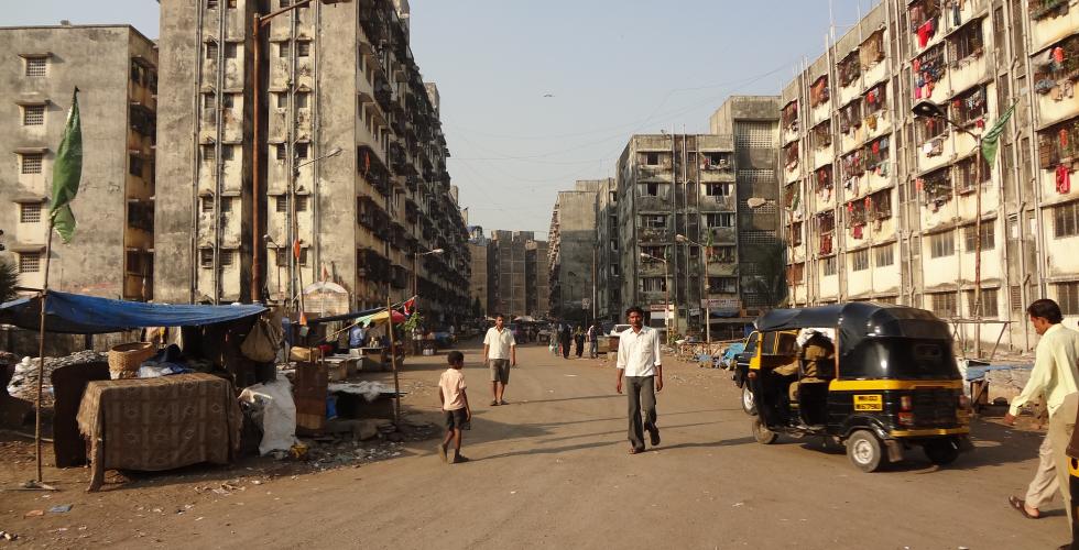
The first Mellon-supported seminar on topics related to spatial inequality. Offered first in Spring 2020. This seminar asks how spatial politics intersect with economic inequality and social difference (race, gender, caste, and ethnicity) to produce marginalized and stigmatized spaces such as “favelas,” “slum,” and “ghettos.” The seminar draws on the convergent yet distinct urban trajectories of Bombay/Mumbai and Rio de Janeiro as a place from which to explore questions of comparative and global urbanism from an explicitly South-South perspective.
2018-2019
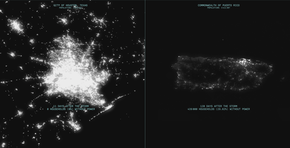
This is the fourth in a series of multidisciplinary Mellon seminars on the topic of Conflict Urbanism, as part of a multi-university initiative in Architecture, Urbanism and the Humanities. The seminar focuses on the role of natural and economic disaster in terms of the spatial restructuring of Puerto Rico today.
This course introduces key concepts and techniques in interactive data visualization to students who are new to the field of computation and information design. Through a series of in-class exercises and take-home assignments, students will critically engage with visual representations of data and produce interactive visualizations that serve analytical and narrative purposes.
This course provides an introduction to critical mapping theory and geographic information systems tools. Of particular interest to Humanities students, we will address both historical and contemporary questions of space and mapping. Through the use of open-source GIS software (qGIS) and data (OpenStreetMap) students will learn how to critically use mapping tools and geographic data for spatial analysis and representation.
In this course students will explore new forms of site analysis through pairing geospatial analysis, mapping, and storytelling. Society is increasingly dependent on data and computation, a dependence that often evolves invisibly, without any critical assessment or accountability. In New York City, with its mandate to make data public, students have an opportunity to learn how to question data through journalistic lines of inquiry: What data are made public? What do they say about life in the city?
This course introduces students to the emerging methodologies that combine geographic information systems (GIS) with historical thinking. Students will study and evaluate the benefits and limitations of key works in historical GIS, become familiar with basic principles of cartographic design, and learn technical skills to create their own HGIS project.
2017-2018
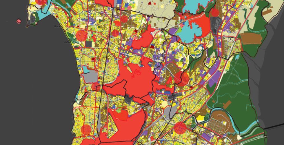
This seminar focuses on infrastructure as a major force in shaping cities, as well as a medium through which the politics of urbanization is visible. Our work will address historical comparison and the politics of mapping by focusing on three cities and three continents – Mumbai, Johannesburg and Medellin. This is the third in a series of multidisciplinary Mellon seminars on the topic of Conflict Urbanism, as part of a multi-university initiative in Architecture, Urbanism and the Humanities.
An introduction to data visualization theory and methods for students entirely new to the fields of computation and information design. Through a series of in-class exercises and take-home assignments, students will learn how to critically engage and produce interactive data visualization pieces that can serve as exploratory and analytical tools.
This course provides an introduction to critical mapping theory and geographic information systems tools. Of particular interest to Humanities students, we will address both historical and contemporary questions of space and mapping. Through the use of open-source GIS software (qGIS) and data (OpenStreetMap) students will learn how to critically use mapping tools and geographic data for spatial analysis and representation.
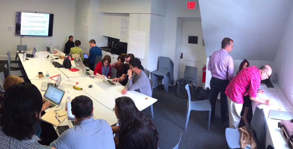
Mapping for the Urban Humanities is an intensive workshop on digital mapping designed for humanities faculty and advanced graduate students at Columbia University. This hands-on workshop is intended to broaden and transform the disciplinary locations within which data analysis takes place. The course introduces participants to open-source mapping software, QGIS, to methods of data collection and creation, and to approaches and concepts in critical spatial analysis.
In this course students will explore new forms of site analysis through pairing geospatial analysis, mapping, and storytelling. Society is increasingly dependent on data and computation, a dependence that often evolves invisibly, without any critical assessment or accountability. In New York City, with its mandate to make data public, students have an opportunity to learn how to question data through journalistic lines of inquiry: What data are made public? What do they say about life in the city?
2016-2017
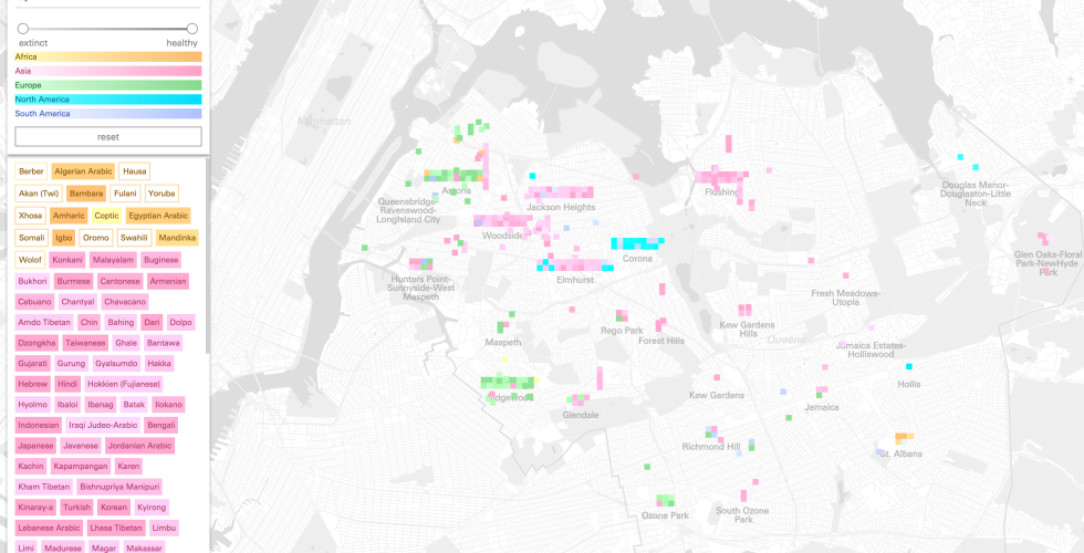
Conflict Urbanism: Language Justice is a seminar to explore how urban spaces are shaped by their linguistic diversity. With a focus on New York City and the estimated 700 languages spoken here, this course examines the results of extreme linguistic diversity and the effects of so many languages coming in to contact and conflict.
An introduction to data visualization theory and methods for students entirely new to the fields of computation and information design. Through a series of in-class exercises and take-home assignments, students will learn how to critically engage and produce interactive data visualization pieces that can serve as exploratory and analytical tools.
Mapping for the Urban Humanities is an intensive workshop on digital mapping designed for humanities faculty and advanced graduate students at Columbia University. This hands-on workshop is intended to broaden and transform the disciplinary locations within which data analysis takes place. The course introduces participants to open-source mapping software, QGIS, to methods of data collection and creation, and to approaches and concepts in critical spatial analysis.
2015-2016
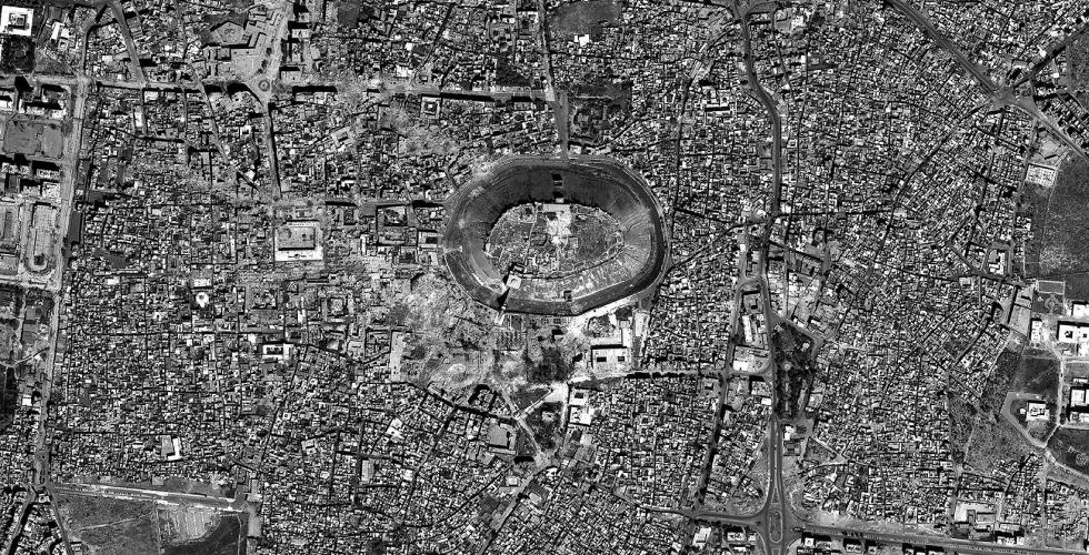
The first in a series of multidisciplinary Mellon seminars on the topic of Conflict Urbanism, conducted as part of a multi-university initiative in Architecture, Urbanism and the Humanities. This Spring 2016 seminar focuses on Aleppo in Syria. Conflict Urbanism is a term that designates that cities are not only destroyed but also built through conflict.
Mapping for the Urban Humanities is an intensive workshop on digital mapping designed for humanities faculty and advanced graduate students at Columbia University. This hands-on workshop is intended to broaden and transform the disciplinary locations within which data analysis takes place. The course introduces participants to open-source mapping software, QGIS, to methods of data collection and creation, and to approaches and concepts in critical spatial analysis.